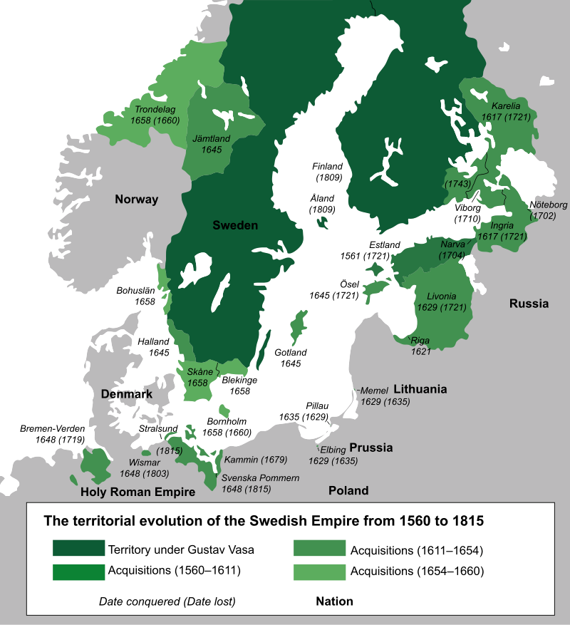
The above map is used to help people develop a new understanding of geography. If I had begun with a map of post World War II Scandinavia, or north America, it would have looked conventional. The map of Swedish territories in the 17th century, shows how this part of the world was in a state of flux.
When, I look at the above map, my focus is on Trondelag. With the exception of a three year period from summer 1985 to summer of 1988, when we lived in Bodø, in Nordland county, further north and off the map, we have lived our entire time in Norway, starting in the summer of 1980 in this light green area, which also includes Trøndelag county (previously separate North and South counties, that amalgamated 2018-01-01) as well as the northern part of Møre og Romsdal county, where we lived from 1980 to 1985. Altogether, that is more than forty years, considerably more than the thirty years, Trish and I spent in British Columbia.
Trøndelag is adjacent to Jämtland, originally a republic. Trøndelag could have become a part of Sweden. Jämtland could have become a part of Norway. It still aspires to regain its independent status. If it were not for the happenstance of military incompetence, it is quite likely that Trøndelag would have become an integral part of Sweden!
My hope is that this map will help people make sense of today’s Nordic area, because the current borders can no longer taken as a given, they have a history.
I started out researching this post by googling urb. The top result directed me to a website for a cannabis dispensary in Michigan. This seems to represent one of the major challenges for geography in the 21st century: people looking for places to numb their brains: tobacco, alcohol and worse; resorts; shopping meccas. For me, this is an inappropriate approach to life. Others will have to make their own decisions.
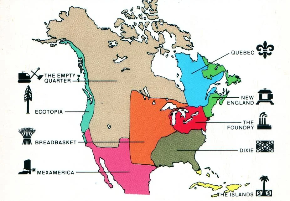
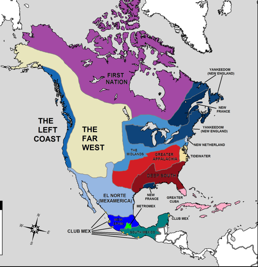
The literary starting point of this post are two books. Joel Garreau (1948 – ), The Nine Nations of North America (1981) and, thirty years later, Colin Woodard (1968 – ) American Nations: A History of the Eleven Rival Regional Cultures of North America (2011).
Most of my north American life was lived in Ecotopia = The Left Coast = The Wet Coast (in other sources). However, in my childhood many of my summers were spent in The Empty Quarter = Mountains West, where my mother, Jennie (1916 – 2021) experienced her early years. She was impacted by life there. My father, Mac = Edgar (1906 – 1991), was an ingrained west coaster. I remember learning about those rough American gold miners, sailing up from San Francisco to exploit a new gold field along the Fraser river in 1858. Later, my paternal great-uncle Robert McGinley Ellis (1863 – 1936) was a prospector during the Klondike gold rush (1886-1889). While I have cuff links from his efforts, I suspect fortune eluded him. He was born in Pakenham, Ontario, moved west to the Jumping Pound, Alberta, where his parents homesteaded, then moved onwards with them to Vancouver Island. He spent most of his life working as a carpenter in Port Alberni on Vancouver Island. He died in Port Coquitlam, in the lower mainland of British Columbia.
The following books have given me insights into north America. Of course, they are not the only works, although I admit a penchant for books about the west, increasingly California. In terms of atlases and railways, I have digested many different works – especially atlases – by Derek Hayes (1947 – ) and by Obi Kaufmann (1973 – ). Using the verb read with an atlas seems inappropriate. Yes, texts are read, but one spends ones time examining maps. Then there are other books, written by others: Marc Reisner (1948 – 2000) best known for Cadillac Desert (1986). Yes, the book is read, but so many other works are consulted to understand the rivers and assorted dams built. In many ways, I am more attracted to Lynn Ingram (? – ) & Frances Malamud-Roam (? – ), The West without Water (2013). More than a quarter of a century probably helps people to focus on the essence of a problem. The American west is not an expensive = Cadillac desert, but a wilderness without sufficient water to transform its existence.
These works provide me with insights into a newish geography, especially geographical terms needed to describe geography in the 21st century. The most important resource is water. One important duty is to allow forests to burn, regularly. I am reminded of that with the titles of two of Obi’s books: State of Water: Understanding California’s Most Precious Resource (2019) and State of Fire: Why California Burns (2024). As the subtitles emphasize, state in the title refers not to a specific condition, but to California. That said, I have nothing against Smokey Bear, discouraging people from starting wildfires.
On 2014-07-03, Joel Garreau, in the New York Times, claimed he began writing his book in the 1970s, when journalists were trying to discover how north America worked. He wants people to forget rectangular images of states, provinces and regions printed on maps, but to understand that north America is a clash between warring civilizations. A map based on culture and values does not reflect the perversely drawn state and national boundaries.
This attempt at understanding resulted in his 1981 book. Garreau comments that reader reaction was astonishing. His map revealed something much deeper. It was a map of culture and values. The idea of nine nations idea became a cult item among marketers, broadcasters, political operatives and even carmakers, who need to understand the north Americans tribes/ nations, how they emerged and how they function. Other authors have adopted the same methodology to explain China, Europe, Mexico, the former Soviet Union and the Middle East. I remember from my anthropology lectures at Dalhousie, about how the Druzes successively realigned themselves with the powers that be in Palestine, in an effort to retain their autonomy.
There were independent nations within American territory. The Iroquois Confereracy (1500 – 1775) is the longest lasting. It consisted of the Mohawk, Oneida, Onondaga, Cayuga and Seneca nations. After 1722, the Iroquoian-speaking Tuscarora people from South Carolina moved northwards, and joined as the sixth nation. This would have only been an academic footnote if I had not learned of my Mohawk ancestry, as a descendent of Ots-Toch (1600 –1646).
There is also the California Republic, a ministate that lasted for 25 days in 1846. Some are hoping that by the 200th anniversary of that republic, in 2046, there will be a new, improved and larger California Republic to replace it. The question is: Does California seek independence alone? Does it attempt to find allegiances with other current or former Mexican territories (Baja California, Dereret, Arizona and New Mexico)? or does it attempt something further north – Washington, Oregon, a strip of British Columbia?
There was also the Republic of Texas = República de Tejas (Spanish), a sovereign nation in North America that existed for almost 10 years, from 1836-03-02, to 1846-02-19. It shared borders with Mexico, the Republic of the Rio Grande – another sovereign nation, occupying what is now north-east Mexico, with its capital Laredo. and the United States. The Republic had diplomatic relations with various countries. Initially, the United States recognized Texas’ independence. The annexation of Texas by the United States in 1845, led to the Mexican–American War from 1846–04-25 to 1848-02-02.
The boundaries of Garreau’s nine nations are unchanged, after more than forty years. They have resulted in an American national gridlock, and the current division into red and blue states, even if I personally feel that the colours should be reversed. I note that my daughter lives on the left coast/ ecotopia, and not just some random location in USA. I can understand its appeal = warmth. Yet, I would be surprised if she left this strip of land for any other place in USA. No, I never expect her to become a Texan. I expect that for her the only American places with appeal are along the left coast and Hawaii. She had been indoctrinated with Cascadian values since she was a child.
Despite the turbulence in technology, finance, energy, population, mobility and polity, the boundaries as drawn in 1981 still make sense – even where events have gone exactly opposite his expectations. For example, North Carolina is even more “Dixie” today than when he wrote about it. He asks readers to check the last few presidential election results at the county level, and one will see these boundaries still influencing (voter) behaviour. He claims that the results in Canada are even more striking.
One explanation for this endurance may be that those boundaries were observed by a network of amateur anthropologists, residing all over the continent. This network documented the existence of these nations. Cultures and values endure. They change more slowly than Garreau first envisioned. He claims there are layers of unifying flavor and substance that define these nations, explaining the major storms through which public affairs pass. The Nine Nations is also a map of power, money and influence, the patterns of which have only deepened.
At this point in time, with Donald Trump and Elon Musk moving fast and breaking things, one wonders what will be happening in the United States in the coming months and years ahead. How much chaos will the American public tolerate?
Travel is still the great North American pastime because of our enduring diversity. Out of a sense of adventure, people still look forward to picking up their belongings and taking a new job in a different place. Trying on different values, different senses of the pace at which life should be lived, different attitudes about art, food and ethnic origin, a different relationship to nature. Yet every North American also knows a place where, on their way back from their wanderings, surroundings stop feeling threatening, confusing or strange. It is a place within their comfort zone.
Here are some concepts that have been presented, along with definitions. In general, the definitions provided come from Wikipedia. My internal map of north America is largely inspired by Garreau’s map, supplemented by that of Woodard. For me, the differences between the two maps, encourage an internal discussion. For example, with a new found discovery of an ancestry in Upper New York state, I ask why New Netherland (on the Woodard map) does not extend further north? It seems to represent just New York, or New Amsterdam.
Edge city = a concentration of business, shopping, and entertainment outside a traditional downtown or central business district, in what had previously been a suburban, residential or rural area. The term was popularized by the 1991 book Edge City: Life on the New Frontier by Joel Garreau. Garreau argues that the edge city has become the standard form of urban growth worldwide, representing a 20th-century urban form unlike that of the 19th-century central downtown.
Suburb = an area within a metropolitan area which is predominantly residential and within commuting distance of a large city. Suburbs first emerged on a large scale in the 19th and 20th centuries, as a result of improved rail and road transport, which led to an increase in commuting. In general, they are less densely populated than inner city neighborhoods within the same metropolitan area, and most residents routinely commute to city centers or business districts via private vehicles or public transits; however, there are many exceptions, including industrial suburbs, planned communities, and satellite cities. Suburbs tend to proliferate around cities that have an abundance of adjacent flat land.
Boomburb = a large, rapidly-growing city that remains essentially suburban in character, even as it reaches populations more typical of urban core cities. It describes a relatively recent phenomenon in a United States context. The boomburb I am most familiar with is Bellevue, in Washington State.
Exurb = an area outside the typically denser inner suburban area, at the edge of a metropolitan area, which has some economic and commuting connection to the metro area, low housing-density, and relatively high population-growth. It shapes an interface between urban and rural landscapes, holding a limited urban nature for its functional, economic, and social interaction with the urban center, due to its dominant residential character. Exurbs consist of agglomerations of housing and jobs outside the municipal boundaries of a primary city and beyond the surrounding suburbs.
Recently, I sent a map (see below) and some instructions for the California game, to people I know living there. The main rules is that a person can play this game as often as they like, hopefully generating new content each time. This game differs from two other California games: A) Include California in Cascadia, and B) Imagine California as an independent country. This game, C) involves keeping California in USA, but dividing it into several different states, each with two senators! Other rules: 1) Decide how many states you want to create out of California. 2) Find sufficient pencil crayons with distinctive colours, one for each proposed new state. 3) Use the existing counties as potential dividing lines. 4) Find the borders. 5) Enjoy the colouring.
People living in other states, say Kansas, could also play a similar game with their own state.