Wikipedia tells us that demography is the statistical study of human populations: their size, composition and how they change through the interplay of fertility, mortality and migration. In trying to learn more about the population of Newfoundland and Labrador I consulted Statistics Canada data, but allowed Wikipedia editors to summarize some findings to gain further insights. Since entering confederation in 1949, Newfoundland and Labrador have always been the 9th most populated Canadian province.
In terms of provinces, only Prince Edward Island is less populated, at about 177 000. On 2024-04-06, Statistics Canada’s population clock indicated that New Brunswick’s population had grown to 850 000. Nova Scotia has seen record population growth in recent years, with young people moving in from Ontario and other provinces. Nova Scotia is attempting to reach 2 000 000 by 2060, but faces challenges in health care, education and housing.
Newfoundland and Labrador (NL) reached their maximum population in about 1991, at somewhere around 568 500 people. Since then, it has declined, reaching about 510 500 people in 2021, the last census year. More than half live on the Avalon peninsula.
Labrador has an area of 294 330 km2 and a population in the last census (2021) of 26 655.
In terms of NL, one has to ask why its population has stagnated, if not declined? NL has been overly dependent on one resource, fish, and cod in particular. There are some exceptions. In Corner Brook and Grand Falls – Windsor, there is an emphasis on forestry and pulp and paper production.
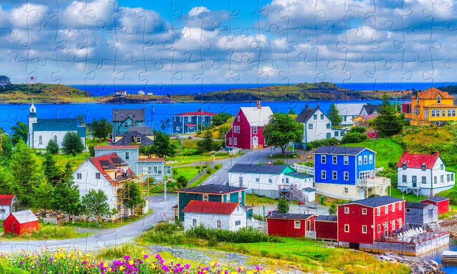
In the following section, a comparison will be attempted between Trinity and Twillingate. Both are small villages, yet they are very different.
Trinity
This is not just a photograph of Trinity, Newfoundland. It is also a screenshot of a jigsaw puzzle I created on 2024-07-21, using 1 hour 44 minutes and 53 seconds to complete the puzzle.
If I have one piece of advice to travellers to Newfoundland, it is to avoid visiting the village of Trinity. The problem with Trinity, is that they have done everything right to make it into a model village. It is more Disneyland, than a thriving village.
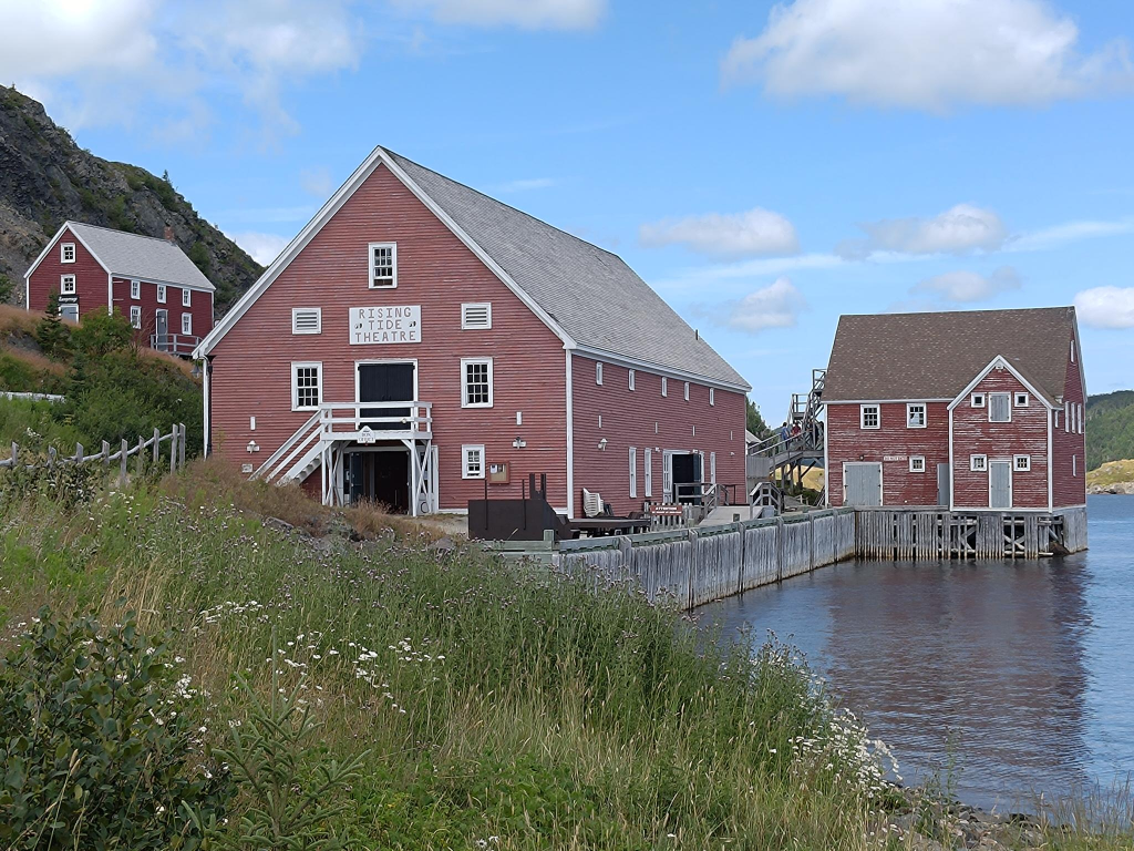
The Rising Tide Theatre is one of many attractions in Trinity.
There are many attractions in the village, including the Rising Tide Theatre. However, there is little coordination, and almost no parking. We were able to park at the museum because it was closed for an hour long lunch in the middle of the day.
Twillingate
About 300 km north-west of Trinity, and about 112 km = 1.5 hours driving, north of Gander, is the town of Twillingate, with a population just over 2 000. It calls itself the Iceburg capital of the world. To arrive there, one travels across several islands connected by causeways, including New World Island, which commemorates the 1523–24 expedition of Giovanni da Verrazzano (1485–1528) to Newfoundland that established the coast to be part of the New World rather than Asia. Yes, that was over 500 years ago! Fogo is the one island in the area still requiring a ferry connection.
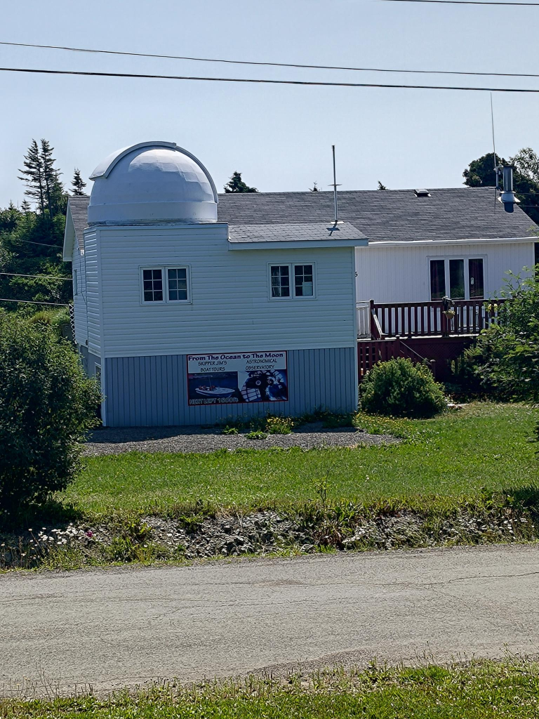
Our stay there was the most refreshing of the trip, we rented a cottage outside of the town. Across the street from our cottage, retired fisherman Jim Gillard has expanded his horizons, setting up a $16 000 telescope in the hand-built Twillingate Astronomical observatory, in his front yard.
Across the street from our cottage, Skipper Jim had opened the Twillingate Astronomical Observatory. It was a way to transform a hobby into a livelihood, and less competitive than turning a fishing boat into a whale watching vessel.
This is not the only attraction. A few hundred meters away, is the Top of Twillingate walk, which provided a refreshing view of the area. This is the one part of Newfoundland that I would want to visit again. We also visited the town, which is divided between two islands, South and North Twillingate. We also visited the Long Point lighthouse, located in the town (?) of Crow Head, also located on North Twillingate. The town’s current population is 156, and declining.
Low Mist Pond with the Top of Twillingate pathway around it.
Travelling to New France from St. John’s, Newfoundland involved a day of travel: one drives on the Trans Canada Highway across the Avalon peninsula to the Burin peninsula, then turns left at Goobies onto Highway 210. One keeps driving on it, until one reaches Marystown. A right turn onto Highway 220, leads to the port of Fortune, which is where the SPM ferries dock in Canada. From there those with vehicles reverse onto the ferry, so they can drive forward when they arrive in Saint-Pierre. Altogether, this involves 363 km and almost 4 hours of driving. The ferry from Fortune to Saint-Pierre is about 45 km, and takes another 1.5 hours.
If one is fortunate in Marystown, one meets the Little Green Devil, a 1965 Rambler American 2-door sedan. This model, and many others in the Rambler lineup, was designed by Dick Teague (1923 – 1991). From my perspective, it is Teague’s most successful design. These vehicles are known for their smooth ride, despite their compact size. WhiIe I would not criticize anyone’s vehicle preferences (with the possible exception of motorcycles), i prefer utility vehicles ( vans and station wagons). Vehicle solidity is my focus. Thus, I prefer vehicle construction incorporating a frame around every door, in contrast to flimsier hardtop models. Despite having a driving license since Tuesday, 1965-01-05, I have owned only four vehicles, including one jointly with my wife, Trish.
At Fortune, we were able to eat a chicken dinner at Mary Brown’s. This was our first experience of this fast food chain. Originally it was named Golden Skillet, the first location was at St. John’s Avalon Mall. However, the owners were forced to rename the establishment for legal reasons. Currently, there are over 300 locations across Canada.
After that meal we picked up our ferry tickets, then went next door to arrange to park our rental car for two days on the outskirts of town. We were driven back to the ferry terminal. The 1.5 hour ferry ride was uneventful. There was little to see apart from waves on the ocean, despite having window seats.
St. Pierre
The Overseas Collectivity of Saint-Pierre and Miquelon = Collectivité d’outre-mer de Saint-Pierre et Miquelon (referred to hereafter as SPM) has a population of about 6 000, and occupies an area of 242 km2 on eight islands. It is located about 19 km west of Point May on the Burin peninsula.
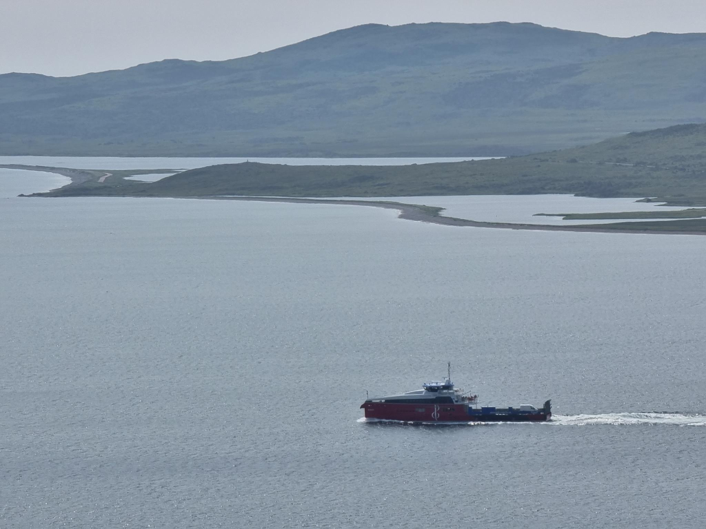
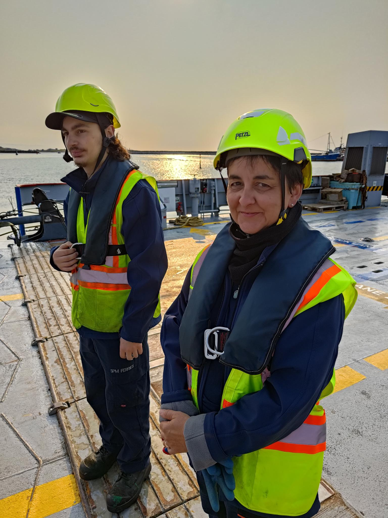
Two almost identical ferries provide for much of the transportation needs of the archipelago. These are the blue hulled Nordet and the red hulled Suroît. The vessels are 56.7 m long, with a 768 UMS tonnage. Both entered service in 2019. They are named after a northerly, and southerly wind, respectively.
Compared to the casual, and often inappropriate dress of deck crew on Norwegian ferries, the deck crew of these French ferries were dressed for any emergency. They were equipped with helmets, hi-vis vests, life preservers, gloves and safety shoes.
After landing in St. Pierre, we passed through French immigration and were able to enter France. We walked through the town, until we found our bed and breakfast, where we had rented two rooms. This was followed by yet more walking around the town. The gradient was intermediate to my two reference points. It was steeper than most places in Inderøy, Norway, but not as steep as the worst hills in New Westminster, British Columbia, Canada.
St. Pierre, the island and village is named for St. Peter, the patron saint of fishers, net makers and ship builders. He was born Simon, possibly Simeon. Both he and his brother Andrew were themselves fishers, later, they became two of the twelve apostles. Details of Peter’s life are vague, although he was the Bishop of Rome = Pope, from 30 AD to his death 64 – 68 AD, crucified by Nero (37 – 68).
While Saint-Pierre is far too urban for my tastes, with a population over 5 000, and an area of 26 km2, Grande Miquelon is appropriately populated (ca. 700 people) and sized (110 km2). If I lived there, I am sure that I would want to spend much of my time in the wilderness of Langlade.
Air Travel
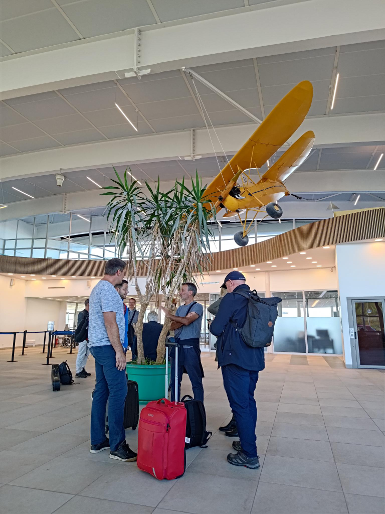
One of the main reasons for wanting to visit SPM was to experience flights with Air Saint-Pierre. We were going to fly both ways on inter-island flights between Saint-Pierre and Miquelon.
On Monday, 2025-07-23, we left our bed and breakfast at 07:30 and walked to Aéroport de Saint-Pierre = Saint-Pierre Airport (FSP), a regional airport located south of Saint-Pierre. It opened in 1999 and consists of four buildings excluding the control tower. It replaces an older airport that opened in 1965. The new 08/26 runway is 1 800 m long, while the old 11/29 runway was 1 250 m, not long enough for most commercial aircraft.
The passenger terminal at 2 200 m2, is large given the traffic.
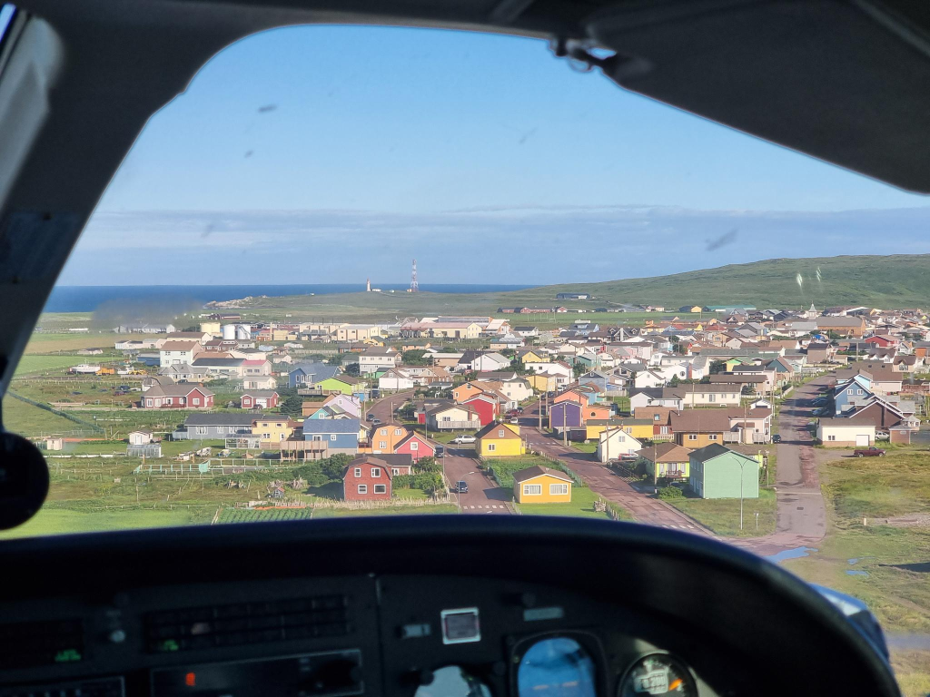
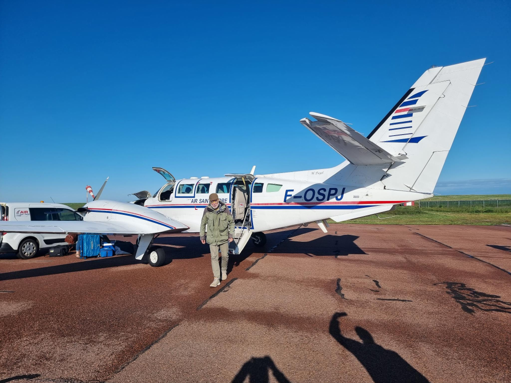
We boarded our aircraft at about 08:30, without any form of security check. It took about 10 minutes to get the aircraft in condition to fly. After about 15 minutes in the air, we were landing at Aéroport de Miquelon = Miquelon Airport (MQC), the regional airport on Miquelon Island. The 12/30 runway is only 1 000 m long, suitable for the Reims-Cessna F406 Caravan II machine, but nothing much larger.
Our return flight was delayed, because the number of passengers exceeded the number of seats available. Thus, we had to wait until the plane flew to Saint-Pierre, then returned to pick us up. Alasdair was happy that he was issued seat 1A for both flights. I was assigned 1B for both flights.
Flying close to the village of Miquelon, on a landing approach. Photo: Alasdair McLellan.
Here I am emerging as the last passenger out of our aircraft, a Reims-Cessna F406 Caravan II of unknown vintage. Photo: Alasdair McLellan.
The Suroît off Miquelon.
I have experience with ferries, of various types, especially from six years with weekly commutes in Norway between Molde and Inderøy, usually involving four ferries each week. I appreciate their efficiency, especially in docking, unloading and loading vehicles. However, I note the lack of crew safety equipment.
Here, the deck crew of Suroît are dressed for any emergency. They are equipped with helmets, hi-vis vests, life preservers, gloves and safety shoes. Later, I talked with Fréderique Ragot, about her work.
Visiting remote airports and train stations is one of the perks of being the parent of someone who studied transportation economics, then took a B.Com. with a marketing specialization, before turning to history, ending with a M.A. and a thesis about the development of a now-defunct Norwegian airline.
Regional Influences
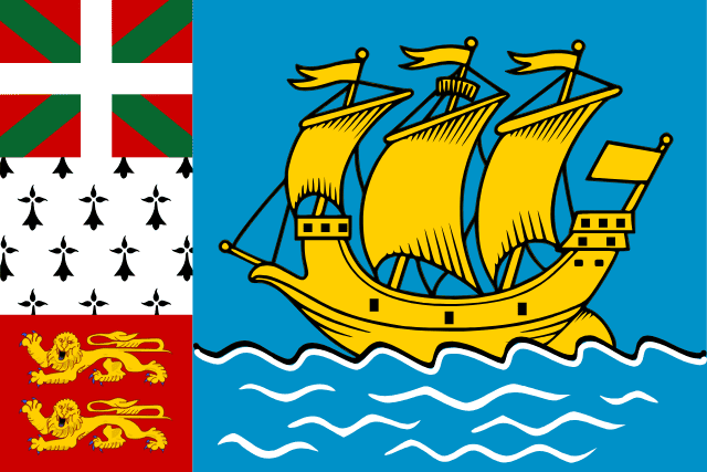
While the official flag of SPM is the French flag, an unofficial SMP flag is also used. Because of my interest in flags, often collecting them from places I visit, I wanted to buy a SPM flag. This proved impossible. Much of the flag contains elements found on the SPM coat of arms. Along the hoist, from bottom to top, are the flags of Normandy, Brittany and, in the uppermost position, the Basque Ikurriña, officially described as a white cross over a green saltire on a red field. Basque nationalists Luis Arano (1862 – 1951) and his brother Sabino (1865 – 1903) developed the Basque flag. Its neologistic name comes from ikur ‘mark, sign’ (itself a neologism extracted from irakurri ‘to read’). These are the places that contributed most of the population of SMP.
The yellow ship on the flag represents the Grande Hermine, the carrack which brought Jacques Cartier (1491 – 1557) to Saint Pierre on 1535-06-15.
World War II
Yet, another reason for this trip to this part of the world, was to understand the situation my parents encountered when they were stationed with the Royal Canadian Air Force, in Newfoundland, for a large part of World War II. Newfoundland was not yet part of Canada, but British territory. SPM was (and still is) part of France. Decisions often involved four countries, with a theoretically neutral USA wanting to make decisions.
The Third French Republic had begun World War II in 1939-09-03 on the side of the Allies. On 1940-05-10 it was invaded by Nazi Germany. Paul Reynaud (1878 – 1966) resigned as prime minister and was replaced by Philippe Pétain (1856 – 1951). On 1940-06-22, Pétain signed an Armistice that created Vichy France that, on paper, existed from 1940-07-10 to 1944-08-09. Vichy was the seat of government, about 400 km south of Paris.
The Vichy government was authoritarian, antisemitic and, somewhat later, anti-Soviet. Yet, it never joined the Axis powers and was formally at war with Germany. In practice, it was collaborationist. SPM authorities had sworn their allegiance to the Vichy French government.
There were concerns in Newfoundland (NL), Britain and Canada, that the Axis powers might use SPM as a base of operations, offering German submariners an excellent position to re-supply and coordinate attacks upon Allied convoys. Wireless communication and transatlantic cables allowed the islands’ authorities the opportunity to transmit vital information to Vichy France and onwards to German submarine crews about weather conditions, the movements of Allied warships and convoys. There was also concern that local fishery products could be sent to Germany through mainland France.
NL wanted a pre-emptive invasion of SPM. Canada was against this for fear of offending USA. As the Battle of the Atlantic reached Canadian waters in 1941, The Canada–United States Permanent Joint Board on Defence had unanimously agreed that the existence of an uncontrolled and high-powered wireless transmitting station on SPM constituted a threat to the interests of Canada and USA. Yet, USA opposed the use of force to take control of SPM.
Charles de Gaulle (1890 – 1970), Chairman of the (Free) French National Committee 1940-06-18 to 1944-06-03 asked Admiral Émile Muselier (1882 – 1965) to investigate the possibility of invading the islands, then ordered their capture.
On 1941-12-23, a French flotilla, the submarine Surcouf and three corvettes, Mimosa, Aconit and Alysse, sailed from Halifax under the pretense of a training mission. It arrived off Saint-Pierre and disembarked 230 armed sailors. They met no resistance and captured the island in only 20 minutes. Some sources state that Miquelon was captured the same day, others the following day. The Free French authorities organized a plebiscite on 1941-12-25, but only males over 18 years were given a choice of “rallying to Free France or collaborating with Axis powers”. Almost 98 per cent voted in favour of Free French administration.
I find it noteworthy that the French named their largest submarine after a slave trader and privateer, Robert Surcouf (1773 – 1827).
The US Secretary of State, Cordell Hull (1891 – 1955), called the capture of SPM a violation of the Monroe Doctrine. He wanted to prohibit French citizens exercising their democratic rights. He wanted SPM to restore its Vichy government. The Monroe Doctrine, first articulated 1823-12-02, is a United States foreign policy position that opposes European colonialism in the Western Hemisphere. Any intervention in the political affairs of the Americas by foreign powers is a potential hostile act against the USA.
Despite Hull’s protests, this incident was soon forgotten. The Japanese attack on Pearl Harbor, 1941-12-07, and the declaration of war on the USA, by both Japan and Germany, meant that Vichy France had become an enemy.
In the 1930s, many Americans were isolationists, not wanting to involve themselves in wars. Others were sympathetic to the Nazi cause. The situation has not dramatically changed in recent years, with Donald Trump wanting the USA to imitate its past, and for it somehow to become great, again. It is instructive to look at the demographics of the Capitol insurrectionists in Washington D.C. on 2020-01-06. They were predominantly white, male, aged 30+, trained and working as professionals. They were not the downtrodden.
Greatness is not measured by the number of billionaires. I am a limitarian, a believer in putting strict limits on personal wealth, with a maximum vastly below a billion $/ €/ £. One percent of that amount should be sufficient for everyone.
Mountains
Many mountains in the Canadian Rocky mountains were named for French generals prominent in World War I in 1919. Mount Pétain was one of these, located on the border of the Canadian provinces of Alberta and British Columbia on the Continental Divide. Geoffrey Taylor (1952 – 2020), a former University of Calgary professor of infectious diseases, campaigned from 2016 to his death, to remove the name of the Nazi collaborator from the mountain. In 2019, Alberta rescinded Pétain’s name from the Alberta side of the border. In 2022, British Columbia also rescinded the name, leaving the mountain and other features previously associated with Pétain, nameless.
Time
Clocks are an important technology for the world. I appreciate Sandford Fleming’s (1827 – 1915) promotion of 24 worldwide standard time zones, a prime meridian, and use of the 24-hour clock. He saw these as necessary elements for communicating time accurately. I am also glad that there is an International Telecommunications Union (ITU), that has created a world time standard, Coordinated Universal Time (UTC). A weblog post on the ITU is scheduled for its 160th anniversary, 2025-05-17. Here many other aspects of time will be discussed.
In this post, I would like to restrict myself to expressing a minor, but unnecessary, irritation with Newfoundland. At the same time, I would like to thank SPM for not following in its wayward footsteps. This irritation can be expressed as Newfoundland and Labrador, having a time that offsets those of a time zone, by 30 minutes.
This post is being published on Ukrainian independence day = День Неза лежності України, 2024-08-24, in commemoration of the Declaration of Independence in 1991.
In mythology, Avalon is an island, dominated by Arthur’s sister, the sorceress Morgan. It is also the location where Arthur’s sword Excalibur was made, and where Arthur recovers from injuries suffered at the Battle of Camlann. This weblog post has nothing to do with mythology, but the Newfoundland peninsula of the same name, visited by Alasdair and myself starting 2024-07-19. In particular, this looks at three features: the Newfoundland Coastal & Railway Museum, Signal Hill and Cape Spear. Heart’s Content, where the first transatlantic cable between Europe and north America landed, is also situated on this same peninsula, but it will be discussed in a subsequent post, Newfoundland, currently scheduled for 2024-10-05.
Prologue
After walking from the Travelodge to the north terminal at Gatwick, England, in half the time it took to walk there, we were soon boarding our Westjet 737 flight to Newfoundland. This was the fastest flight I have ever taken to North America from Europe, at about 4h 30m. That is, if north America excludes the western/ north American section of Iceland containing KEF = Keflavík airport, and consider all of Iceland as being in Europe.
I have a fascination with some islands and archipelagos. In Canada, I have lived and worked on Vancouver Island, which is where my father was born. I have visited Cape Breton Island, where my McLellan ancestors arrived in the Margaree Valley, over 200 years ago, from South Uist, an island in the Hebrides. Queensborough, part of New Westminster, but not the part where I grew up, is located on Lulu Island. It is, however, the location of the machine works run by my wife Trish’s maternal grandfather.
It took me until this year, at the age of 75, to visit Newfoundland, which has been waiting as a Canadian island to cross off from a bucket list. I have a relationship to it, as both of my parents – Jennie and Mac – served there in the Royal Canadian Air Force, during the second world war. They were married in St. John’s in 1942. Earlier, Trish’s father worked on freighters taking paper from Corner Brook to other places in the world.
On the Westjet 737, I was seated in a middle seat, towards the rear of the aircraft, between Alasdair and Buckers. I had not met Buckers before, but learned she was English, and would be continuing her journey on to Jasper, on another Westjet aircraft, in a matter of hours after her arrival at St. John’s.
Later, we would learn that Jasper had been devastated by wildfires. We also experienced our share of live disinformation, when we were incorrectly told by other tourists that 84 people had died in the fires, and that the arsonist responsible for starting the fires had been arrested. I find it distressing that people can’t be bothered to check facts. My current understanding is that there were two fires, one to the north, another to the south, that met near Jasper. The fires resulted in one death, firefighter Morgan Kitchen (2000-07-23 – 2024-08-03) who died as the result of a falling tree. This occurred after we returned to Norway. At the time of writing, 390 square kilometers were said to have burned, along with 358 structures. No official cause of the fires had been released, and it was under investigation.
When we landed at YYT, St. John’s International Airport, our first task was to acquire our rental vehicle which turned out to be a Ford Explorer, with a 4-cylinder 2.3 litre engine. We were not especially impressed with the vehicle, in part because it consumed large quantities of fuel, and did not respond well with its adaptive speed control. On a more positive note, Newfoundland’s infrastructure for electric vehicles was not built out, so I should be thankful that we opted for an ICE vehicle.
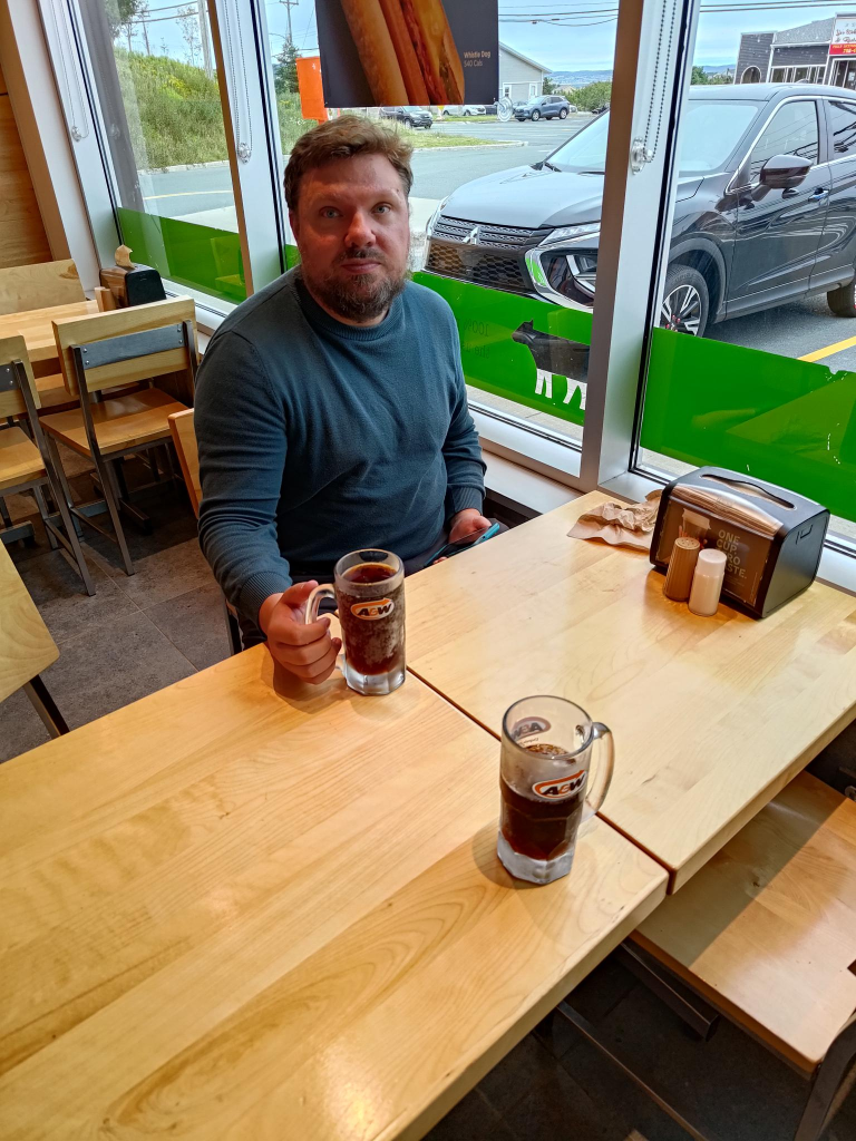
Alasdair, drinking his first mug of rootbeer on this trip, 2024-07-19.
We then needed to eat a meal, which occurred at a local A & W, immortalized in the photo above. Rootbeer is the only beverage I miss from Canada, after 44 years of living in Norway. I drink it to excess when in north America, knowing that it could be several years before I experience it again.
After dinner, we found our accommodation: two rooms with kitchenettes, at Crossroads. This housing complex seemed to have been designed for weekly commuters, coming from the outports, but working in the St. John’s metropolis.
Railway & Coastal Museum
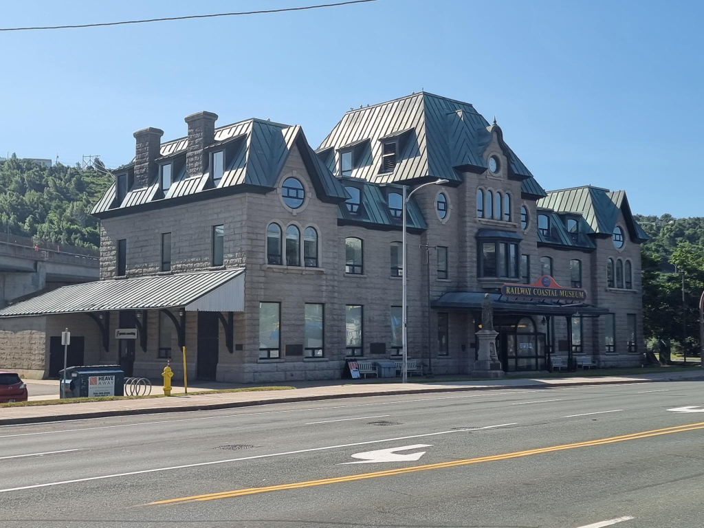
The Railway & Coastal Museum in St. John’s, Newfoundland, visited on 2024-07-20.
On 2024-07-20, we drove into downtown St. John’s. Our first stop of the day was at the Newfoundland Railway &Coastal Museum, the former railway station. There haven’t run trains on Newfoundland since 1988. The railway was augmented with ships, which is why the term coastal is applied to the museum.
The Newfoundland Railway was a narrow-gauge railway that operated in Newfoundland from 1898 to 1988. It had a total track length of 1 458 km. It used 3′ 6″ gauge = 1 067 mm.
Prior to leaving Norway, Alasdair had purchased, and I had read Les Harding’s (? – )book: The Newfoundland Railway, 1898-1969: A History (2014). It provided a good overview of the topic. The museum exhibits kept reinforcing the content in the book. I was less impressed with the rolling stock on display.
Prior to leaving the museum, Alasdair had purchased three additional books about rail transport in Newfoundland, all written by Kenneth G. Pieroway (? -): Rails Around the Rock (2014), Streetcars of St. John’s (2019) and Trains of Newfoundland (2022). We do not have his first book: Rails Across the Rock (2013).
The challenge with rail transport in Newfoundland is that most of the economic development is at points along the coast. This favours ships rather than rail cars. There is also a need for a highway network allowing for the shipment/ distribution of goods, as well as the transport of people. Much of this need for transport is provided by the Trans Canada Highway (T.C.H.), and other highways. In comparison to Norway, travel time is 50% faster in Newfoundland (typically 90 km/h vs 60 km/h). The highways are also wider and straighter.
The low population of Newfoundland means that there is no advantage gained by having two forms of land transport, road and rail. Thus, visiting the railway related exhibits at the Newfoundland Railway and Coastal Museum is a look backwards in time. There is no future on the island for rail!
The inglorious Eastern terminus of the Trans-Canada Highway. Photo: Alasdair McLellan
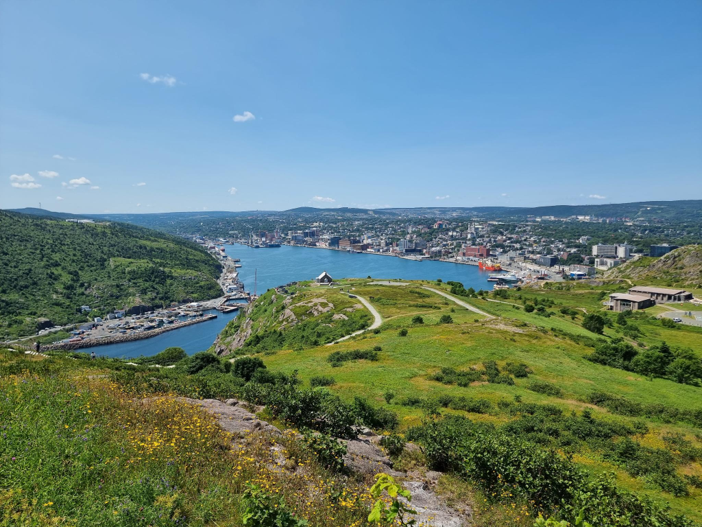
Signal Hill
St. John’s, as seen from Signal Hill. Photo: Alasdair McLellan.
On 1901-12-12, at Signal Hill, in St. John’s, Newfoundland, Guglielmo Marconi (1874 – 1937), listening through his telephone headset, heard a series of three dots, Morse code for S. He had received the first transatlantic communication, from a radio transmitter in Poldhu, Cornwall, England, about 3 500 km away.
This incident illustrates a major challenge. It is easy to propagate and send radio signals. It is more difficult to receive them, and that challenge increases with distance. Marconi was especially drawn to the work of Heinrich Hertz (1857 – 1894), on the transmission of electromagnetic waves through the air.
Marconi started experimentation with wireless telegraphy in 1894. He realized that although messages could be transmitted over long distances through wires, there was great potential in sending messages wirelessly, especially to ships. He discovered that signal range could be increased by grounding the transmitter and increasing the height of the antenna. While born in Italy, he had an Irish mother. Both of his parents had British citizenship. Thus, it was natural for him to move to England in the late 1890s, in part because the Italian government failed to support his work, probably because he lacked a university education.
In 1896 he patented his first wireless telegraphy machine. In 1897 he founded the Wireless Telegraph and Signal Company to manufacture these devices, which were radio sets capable of transmitting and receiving messages in Morse Code. The Royal Navy quickly saw the potential of this technology, and in 1899 equipped three of their warships with these radio sets. Commercial shipping companies quickly followed the Navy’s lead.
A common misconception about radio anno 1900, was that radio waves would travel in a straight line, limiting their distance from the point of origin to the horizon. Marconi believed that radio waves would follow the curvature of the earth. This meant that messages could travel much greater distances. The main focus at the time was on being able to communicate with ships at sea. Even though Marconi believed this to be possible he still had to prove it. His idea was to send a message across the Atlantic, where there could be no doubt that the waves were bending with the curvature of the earth.
The Royal Navy’s decision to try Marconi’s wireless radio systems was based on the success of his 1899 experiment where he transmitted a message across the English Channel to France. It was still unknown how far a wireless signal could be sent.
For a transatlantic transmission, a receiver was set up at Cape Cod, Massachusetts. However, a storm damaged the antenna at Poldhu forcing Marconi to replace it with a shorter one. Because of his doubts about the capability of this shorter antenna, Marconi changed the receiver location to Signal Hill, Newfoundland. A signal was to be sent each day at an appointed time from the transmitter in Poldhu. Simultaneously, Marconi would try to receive the message. The antenna had to be lifted into the air by balloons and kites. High winds resulted in several failed attempts, until they didn’t, and a message was successfully received.
Marconi correctly believed that radio waves followed the earth’s curvature, but misunderstood the mechanism. Waves travel along the ground and through the air. It was not the waves that traveled along the ground that allowed the message to be received but the waves that traveled through the air bouncing off the ionosphere.
With this success Marconi’s company flourished. Newfoundland wanted Marconi to set up a wireless station on the island, at Cape Spear. This did not happen due to a preexisting monopoly agreement between the government and the Anglo-American Telegraph Company where Anglo-American received a fifty-year monopoly on telegraphic communications on the Island in exchange for running a cable from St. John’s to Newfoundland’s west coast and across the Cabot Strait connecting Newfoundland to the rest of North America. This agreement did not expire until 1904, and the company threatened to sue Marconi if he tried to establish a wireless station on the island before that time. To avoid this Marconi decided to construct his station at Glace Bay, Cape Breton Island, Nova Scotia.
Marconi build a telegraph station at Cape Race, Newfoundland in 1904, after the Anglo-American Telegraph Company’s monopoly expired. On 1912-04-14, this station received the distress signal from RMS Titanic.
Marconi made a couple of more trips to Newfoundland to conduct experiments to improve wireless telegraphy and telephony (the transmitting of the human voice) until his death in 1937. Additional insights can be obtained by looking at the Newfoundland Heritage webside, including works by Jeff Webb (2001), and Jenny Higgins (2008). Books on the subject include: Arthur C. Clarke ( 1958) Voice Across the Sea (first edition 1958, second edition 1974); K. W. Hoffman, History of Telecommunications in Newfoundland (1978); Michael McCarthy, Frank Galgay and Jack O’Keefe The Voice of Generations: A History of Communications in Newfoundland (1994).
St John’s Harbour Symphony
While at Signal Hill, we had an opportunity to hear the St. John’s Harbour Symphony, part of the bi-annual Sound Symposium festival with a distinctive sound, now celebrating its 40th anniversary. This is performed daily, for five minutes, one week a year, at 12:30 each day. Volunteers board ships in port and make music using ship’s horns.
Pieces performed are composed using a unique system. Monotone horn blasts are marked as dots in a grid, with each box representing one second. The claim is that this allows music to be accessible for non-musicians. Activities are divided between volunteers. Some will count seconds while an assigned partner operates a horn. Happenstance is part of the Harbour Symphony experience: Sometimes a ship doesn’t show up as planned; sometimes, a horn doesn’t work. Uncontrollable variables result in improvisation.
While I initially found it irritating, I missed it when it was over, five minutes later. Regardless, there is no escaping the Harbour Symphony in downtown St. John’s, or at Signal Hill. Ships are an integral part of St. John’s environment. They have been sailing there for 500 years. Until the cod crisis, they were integral to Newfoundland life, with a mix of the controlled and the chaotic .
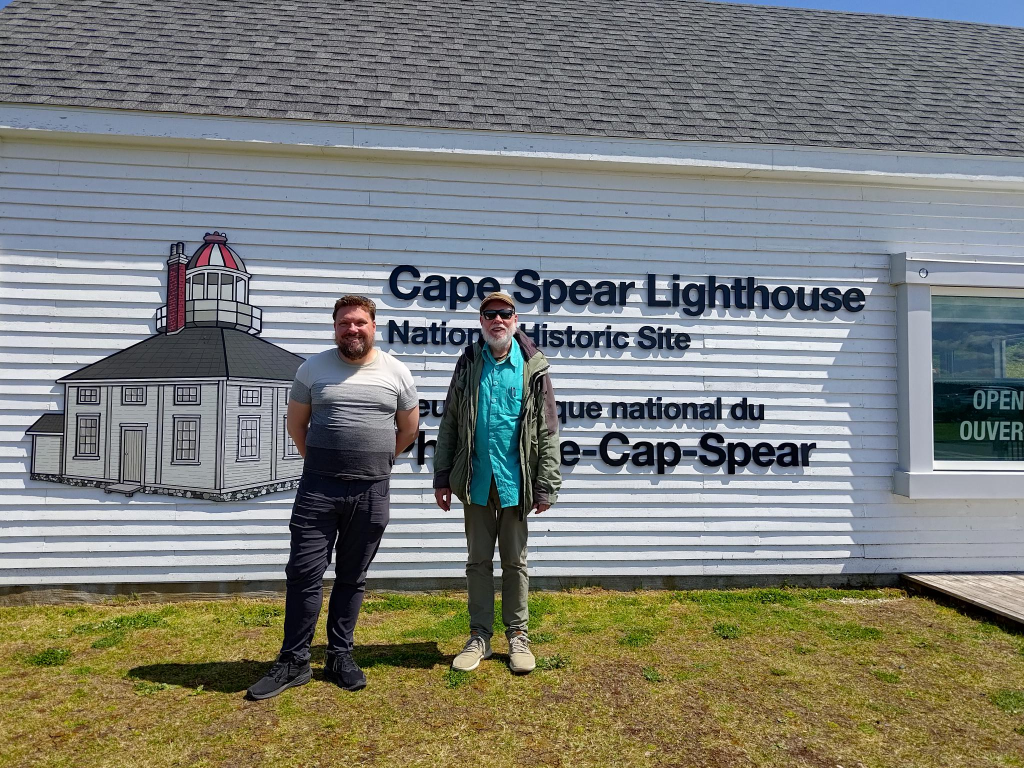
Cape Spear
Documentation of our visit to the most easterly point in Canada. Taken by an unknown fellow tourist.
Yes, we had to visit Cape Spear with its eatery, lighthouse, signs, WWII fortress and significance as the most easterly point in Canada, at least since 1949-03-31: 52°37′11″West. At my birth, Labrador and Newfoundland were not part of Canada. At that time, the most easterly point in Canada was at the Quebec-Labrador border, near Blanc-Sablon, longitude: 57°06’30” West. We visited both places on this trip. Americans can also gain bragging rights at Cape Spear, as it is in contention as the most easterly place in north America. In the contiguous United States, the farthest east anyone can travel is Sail Rock, Lubec, Maine: 66°56′49.3″W. Even further east is Point Udall, St. Croix, U.S. Virgin Islands at 64°33′54″W. Both these places ignore Alaska, and Amatignak Island at 179°8′55″W.
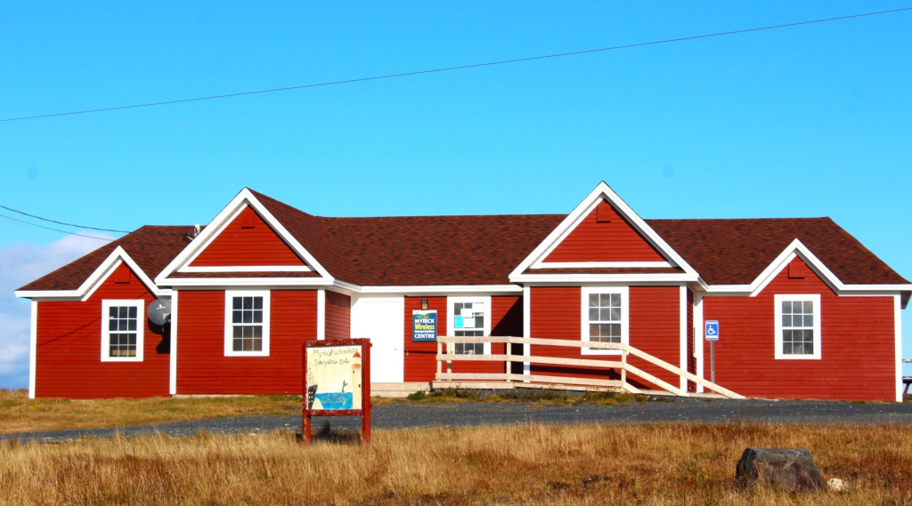
Cape Race
We never visited Cape Race, and the Myrick Wireless Interpretation Centre. It claims to enlighten visitors about the earliest days of wireless communication and telegraphy in Newfoundland. It is named for the Myrick family who lived and worked at Cape Race from 1874 to 2007. Cape Race involves a 155 km/ 2h20m trip from St. John’s, in each direction.
The problem we encountered with Cape Race, was its failure to provide essential information, such as opening times, and a description of the interpretation centre experience. One does not travel long distances anno 2024, in the hope that a venue will be open when one arrives. Similarly, without a description of activities, it is impossible to know if a museum will succeed or fail to tell an interesting story. The last thing anyone wants is a well laid out collection of facts. Listening to some reconstructed version of a mayday signal from RMS Titanic, is not my idea of a well-spent afternoon.
The Myrick Wireless Interpretation Centre
Note : Stop researching for a while and begin to think! Advice from /. = slashdot.org as I started working on this series of posts: I have tried to follow that advice.
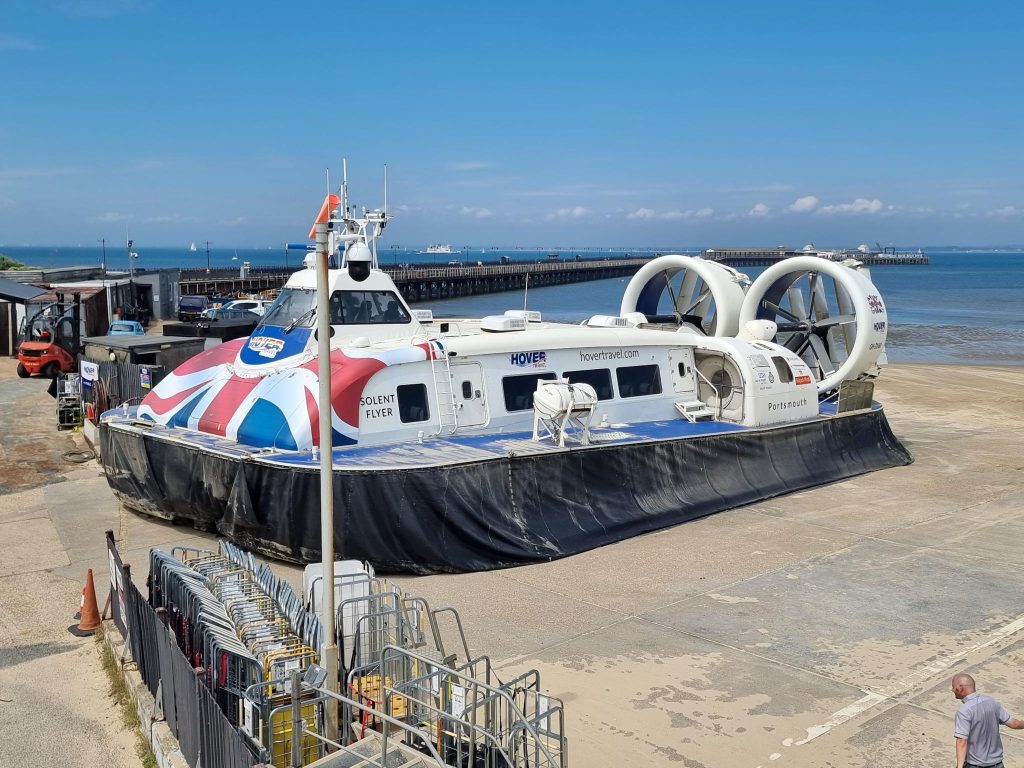
The Solent Flyer, a Griffon Hoverwork 12000TD hovercraft, produced in 2016. Photo: Alasdair McLellan.
Some people may regard a hovercraft as a boat/ ship/ vessel. Those associated with providing hovercraft services do not. For them, it is an aircraft, belonging to its own special category. There are numerous varieties of aircraft: gliders = planes without engines. relying on natural air currents for lift; airplanes = engine-driven, fixed-wing, heavier-than-air craft; rotorcraft (including helicopters and gyroplanes); lighter than air craft (including baloons, zeppelins, dirigibles and blimps); and hovercraft. There are other categories involving parachutes, and weight-shift controls, not to mention rockets.
Hovercraft are distinct, differing from ground effect vehicles and hydrofoils that require forward motion to create lift. Hovercraft can lift themselves without directional movement.
There have been many people involved in the design of hovercraft, and it is incorrect to assign the design to any one person.
Emanuel Swedenborg (1688 – 1772) first mentioned surface-effect vehicles, and used the term hovering in 1716.
John Isaac Thornycroft (1843 – 1928) explored the concept of an air-cushion vehicle in the 1870s, as a way of reducing the drag experienced by vessels.
Konstantin Tsiolkovsky (1857 – 1935), an aerospace pioneer, visionary and author of works on interplanetary space travel, space station construction and airship design, lay the theoretical groundwork for powered movement over a cushion of air.
Dagobert Müller von Thomamühl (1880–1956) built the world’s first air cushion boat (Luftkissengleitboot) in 1915.
The chronological order of people will be disrupted to insert Toivo J. Kaario (1912 – 1970). In 1932, he had decided to build a ground-effect vehicle. This materialized as Pintaliitäjäprototyypin = Surface Soarer Prototype built in 1934, and tested in 1935-01. Patosiipi No. 2 was tested in 1935-1936. The ground-effect wing of Kaario’s early designs had an almost non-existent ability to block the loss of air being blown down by the propeller. The Patosiipi No. 2 was able to lift, but the ground-effect lift was weak. Another full-sized prototype was built with a skirt underneath, which added to the lift by trapping the high pressure air that had been forced. This device was first tested on land and then on the water and was found to be slower but with more lift over an uneven surface.
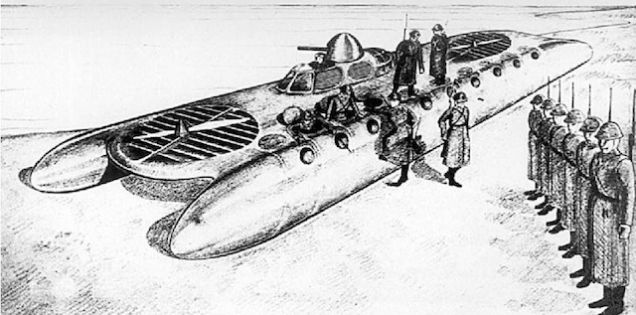
An illustration with two conflicting claims: 1) A sketch made by Toivo J. Kaario, showing an advanced hovercraft design for the Finnish military ; 2) A L-5 hovercraft, for the Red Navy, by the V. I. Levkov Design Bureau.
Aerodynamicist Vladimir Levkov (1895 – 1954) experimented with sidewall hovercraft. He built models in 1927 and 1932. He built a prototype (L-1) in 1934. This could reach a speed of over 60 km/h, but proved to be unreliable. Another prototype (L-5) weighed 8.6 tonnes, was powered by two 664 kW engines. He was aware of the research of Kaario, and used this in his own work. On its cushion of air, it could achieve speeds of 140km/hr = 73 knots.
Levkov was dissatisfied with his results, especially the aviation engines designed to operate at colder temperatures . The Red Navy wanted to press hovercraft into service as soon as possible, and in 1938 some upgraded L-5s saw operational service. A L-5 hovercraft was used to transport the four-man crew of North Pole 1, a Soviet arctic drift station, to an icebreaker after their research was completed.
Cockerell’s hovercraft model from 1955 in the Science Museum, London. Photo: The Wub, 2024-04-22.
Christopher Cockerell (1910 – 1999) bought Ripplecraft Ltd., a small Norfolk boat and caravan hire company. This was not a very profitable venture, but left him time to work on ideas for a hovercraft. He tested his theories using a vacuum cleaner and two tin cans, and found them to have merit. By 1955, he had built a working model from balsa wood and had filed his first hovercraft patent: GB 854211. In the autumn of 1958, the National Research Development Corporation (NRDC) placed an order with Saunders-Roe for the first full-scale hovercraft, designated SR.N1 (Saunders-Roe – Nautical One), based on the prior work of Cockerell. This craft was completed, and first crossed the English Channel From Dover to Calais on 1959-07-25.
Originally, a skirt was not part of a hovercraft design. It was an independent invention made by a Royal Navy officer, C.H. Latimer-Needham (1900 – 1975), who sold his idea to Westland (by then the parent of Saunders-Roe’s helicopter and hovercraft interests), and who worked with Cockerell to develop the idea further.
It should be noted that obtaining patents for ideas related to hovercraft was not always easy. Much of the work was regarded as military secrets.
Approximately, 20 years after the first crossing of the English Channel = la Manche, on 1979-08-03 Trish and I took a trip by Hovercraft from Ramsgate to Calais on a Hoverlloyd craft. Its name remains unknown, and we have no photograph of it. Our letter home, at the time read:
“We left the Roe’s [presumably the people renting us a room] early on Friday morning, stopping near the Ealing Broadway Tube Station for breakfast at the local Wimpy bar (2 eggs and chips, milk). We then took a bus to Acton Town, transferred to a second bus and enjoyed a leisurely ride through the suburbs of London. At Marble Arch we alighted from the bus, walked through Hyde Park ending up at Victoria Station.
“We purchased a ticket for the Hoverlloyd that flies from Ramgate to Calais (at about 2’ above the surface), then took the tube from Victoria to Euston Stations and the Britannia Air Coach Station. After a lunch at a local Italian café, we boarded a coach and enjoyed a tour of the English countryside.
“The Hovercraft crossing took about 40 minutes. The stewardesses aboard were quick to offer duty-free drinks, etc. aboard. Then offer cigarettes, bottles of liquor, a second time. Immigration and customs are easier than at the US/Canadian border. The officer looks to see if you have a passport (he doesn’t even open it) , you are then cleared.
“We then boarded a second coach which toured the French countryside and enjoyed what we could of the trip. At the French/Belgian border, there was no passport control and customs was only interested in the registration of the bus.
“We arrived in Brussels at about 10:00 pm, just late enough for the youth hostel to be closed. Se we spent the first part of the night in a garage. After the wind picked up and made sleeping impossible we moved our shelter to the train station.”
End of quotation from letter.
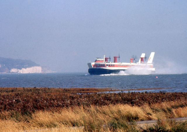
Our 1979 journey was onboard a SR.N4 Mark II. The fuselage had a length of 39.68 m, a width of 23.77 m, a height of 11.48 m and a mass of 200 tonnes. This provided the craft with a capacity of 278 passengers and 36 cars. The four Rolls-Royce Marine Proteus gas turbine engines produced 2 500 kW of power.
A SR.N4 hovercraft inbound in Peggwell Bay, where Hoverlloyd had its British Ramsgate hoverport. Photo: Nick Smith, 1980-08-?.
There is a Hovercraft museum, at Lee-on-the-Solent, Hampshire with the SR.N4 GH-2006 Princess Margaret on display. Another opportunity to see ancient hovercraft in action is in the following films: The Princess Margaret appeared in Diamonds Are Forever (1971) SR.N4 GH-2005 Sure appeared in La Gifle (1974) and in The Black Windmill(1974). An unspecified SR.N4 appeared in Hopscotch (1980).
My next trip on a hovercraft was with Alasdair on 2024-07-18, almost 65 years to the day, after SR.N1’s first trip, and 45 years after my first trip. It was forward and back on the route from Southsea to Ryde, Isle of Wight. This service is provided by Hover Travel, which uses a pair of Griffon Hoverwork 12000TD craft, purchased in 2016. Griffon states that passengers will find this a high quality experience, with cabin noise below 75dB, fast entry and exit, at a top speed exceeding 45 Knots = 83 km/h. The 12000 in the name refers to the payload in kilograms.
Interior of the Solent Flyer. It will seat 80 passengers. Photo: Alasdair McLellan.
Hoverwork’s goals with the Griffon 12000 TD hovercraft, were to create a robust yet light-weight craft, while updating technology and ensuring production quality improvements. They claim these hovercraft offer low running and maintenance costs. Vital measurements: Length = 23.7 m; beam = 12.8m; passengers = 80. Payload 12 000 kg.
From 2024, Oita Hovercraft is operating a 33-kilometre hovercraft route between the city centre of Oita city and Oita airport. Hovercraft were used from 1970 to 2009, but became financially unviable. A hovercraft takes 25 minutes, each way, in contrast to a bus that uses over an hour. Thus, a political decision was made by the Governor of Oita in 2020 to use hovercraft once again. Oita Hovercraft has acquired 3 x 12000TD hovercraft from Griffon Hoverwork, the same type that is used in the Solent.
While this weblog post is mainly about the civilian use of hovercraft, there are also civil defense (including ambulance and fire services) uses. Some uses, by location.
The Canadian Coast Guard uses hovercraft to break light ice. Numerous fire departments around the US/ Canadian Great Lakes operate hovercraft for water and ice rescues. The US Postal Service began using a Hoverwork AP1-88 in 1998 to haul mail, freight, and passengers from Bethel, Alaska, to and from eight small villages along the Kuskokwim River. Hovercraft service is suspended for several weeks each year while the river is beginning to freeze to minimize damage to the river ice surface. Similarly, since 2006, a cargo/ passenger version of the Hoverwork BHT130, has been used as a high-speed ferry for up to 47 passengers and 21 500 kg of freight serving the remote Alaskan villages of King Cove and Cold Bay.
In Scotland, a Griffon rescue hovercraft has been in use with the Airport Fire Service at Dundee Airport. It is used in the event of an aircraft ditching in the Tay estuary. Since 2008, the Red Cross has offered a flood-rescue service hovercraft based in Inverness, Scotland.
In Finland, small hovercraft are widely used for maritime rescue and during the rasputitsa = mud season.
On Madagascar, HoverAid, an international NGO, has used a hovercraft to reach the most remote places on the island since 2006.
Military Uses
In 1996, Lieutenant commander K. L. Schmitz, United States Navy, concluded a report: “The LCAC [Landing Craft Air Cushion] lift capacity, speed, and maneuverability provides greater flexibility to the Marine-Air-Ground Task Force (MAGTF) punch. It will keep the MAGTF at the center of the military’s power projection mission well into the next century. Both the LCAC and LCU [Landing Craft Utility] have served the naval forces well and each has plenty to contribute to future operations. The investment in LCAC has been made; they have proven their value to the naval expeditionary forces. Despite heavy maintenance and operating costs, now is not the time to consider LCAC retirement.”
In the report itself it was noted that LCACs can access 80% of beaches, while LCUs can only access 20%. From this and other reports one can conclude that military LCACs are expensive and temperamental, while LCUs are cheap.
Prologue
Yes, convention states that a prolog(ue) should be placed at the beginning of a work. As people may have noticed previously, I sometimes defy convention. This is one of those situations.
My son, Alasdair, had spent the beginning of July on a road trip through southern Norway, visiting places he had not seen before. He finished his journey at our house, spending a couple of days resting to begin the next part of his holiday, and taking me along as his accomplice.
My wife, Trish, accompanied us to TRD, Trondheim Airport, to drive Buzz home. We entered the terminal building, passed through security, then immigration to exit Schengen territory. We ate a poor, but overpriced breakfast, before we boarded the Norwegian plane, bound for Gatwick. Alasdair was asleep even before the plane alighted from the runway.
On arrival at Gatwick, we used an app to pass through immigration, then walked through customs on our way to the train station. We used a Welsh app to buy train tickets, but not everything worked as quickly as intended. Why a Welsh app? Because one can buy train tickets from numerous providers. For external providers of a journey, a surcharge is added. Except the Welsh are unique. They do not add that surcharge. We arrived at the correct train platform with two minutes to spare. We were on our way to Portsmouth Harbour.
Exiting the train, we bought some provisions at the local Co-op store, then walked south to Hover Travel, and from there soon onto the Solent Flyer.
Interlude on the Isle of Wight
After we arrived at Ryde, we decided to eat dinner. The main problem was that there was a discrepancy between map and terrain. The eateries that Alasdair had found online, did not exist in reality. We decided to eat some Sri Lanken food. It proved to be a foolhardy choice, possibly the worst meal of our trip.
The other task on Wight, was to take the local railway from Ryde to Lake. Lake is one stop past Sandown. One of Trish’s aunts, by marriage, was born at Sandown, but lived some streets away (W 32nd Avenue) in Vancouver, when Trish was growing up. This aunt’s brother, who was also born at Sandown, lived at the end of the block where Trish lived (W 37th Avenue).
The trip back to Ryde was more problematic, because the train was cancelled. It then was necessary to delay our departure time on the hovercraft by one hour.
Epilogue
Once the Solent Flyer arrived back at Southsea, it was time to take a train back to Gatwick, then the shuttle from the south terminal to the north terminal. We had booked accomodation at the local Travelodge. Despite knowing where both ends of the route lay, between the north terminal and the hotel, it was difficult to find the most appropriate pathway. We used about half an hour to cover the distance, walking (and to some degree backtracking).
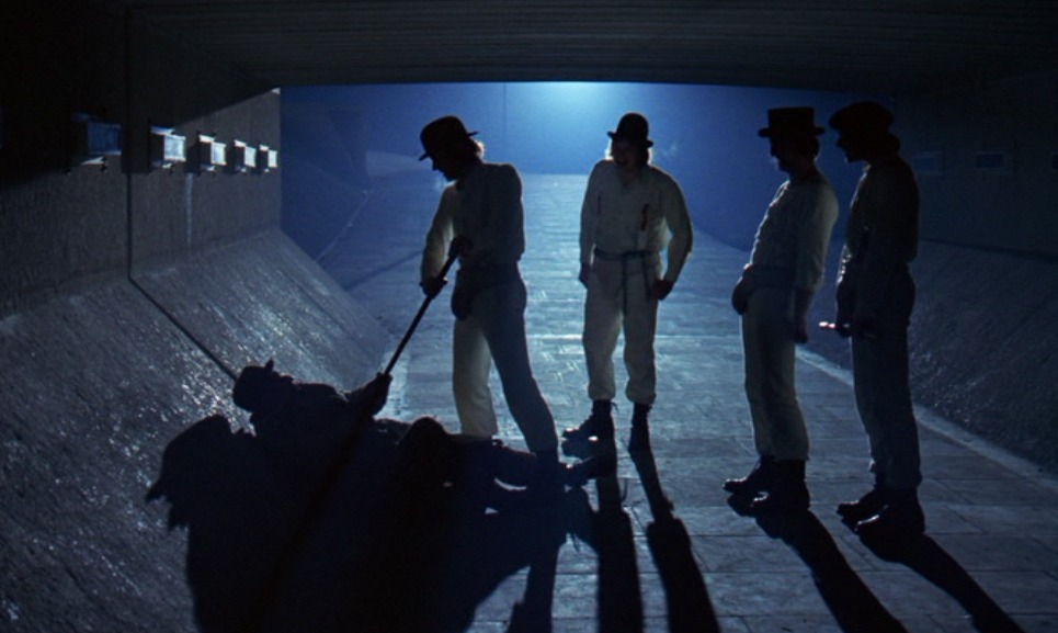
To understand violence, I frequently turned to novels and film, at least in the previous millennium. In particular, I was drawn to A Clockwork Orange. That applies in equal measure to Anthony Burgess’ (1917 – 1993) novel (1962) and Stanley Kubrick’s (1928 – 1999) film (1971). Admittedly, but irrelevantly in terms of this weblog post, I was also drawn to the film by its use of synthesizer music, composed in part, arranged and performed by Wendy Carlos (1939 – ).
Burgess once stated: In 1945, back from the army, I heard an 80-year-old Cockney in a London pub say that somebody was ‘as queer [= mad/ insane] as a clockwork orange’… For nearly twenty years I wanted to use it as the title of something… It was a traditional trope, and it asked to entitle a work which combined a concern with tradition and a bizarre technique.
Beyond gratuitous gang violence there is psychological horror, presented in The Shining. Once again there is a novel (1977) by Stephen King (1947 – ), and a film (1980) by Stanley Kubrick, with synthesizer music by Wendy Carlos. Both involve an exploration of the human psyche, the role of social isolation, and portray one person’s descent into insanity.
I attended a symposium on violence in film in the early 2000s. Part of the reason for it, was in response to the Columbine killings. On 1999-04-20 Eric Harris and Dylan Klebold entered their Columbine, Colorado high school planning to detonate homemade bombs. When that failed they walked through the halls using four guns to injure 24 people and kill 13 more, before killing themselves. The symposium was designed to give teachers a better understanding of violence, how violence could be perceived by students, how violence could be prevented by teachers.
The oldest film screened at the symposium was Dirty Harry (1971), produced and directed by Donald Siegel (1912 – 1991). It is often described as neo-noir, and being based on the Zodiac killer, an unknown, anonymous male, who claimed to have murdered 38 people in the 1960s in northern California. Discussion focused on antihero Harry Callahan (1930 – ?), portrayed by Clint Eastwood (1930 – ), who has his own vision of justice where possession and use of a gun take precedence over human rights, and a rule by law. Teachers cannot be allowed to imitate Dirty Harry in the classroom. Pupils have to be treated justly, perhaps aided with a modest proportion of compassion.
While working on this text I had a discussion about law with my son, Alasdair. We, along with Trish, had taken law courses when we studied business management, not to become lawyers, but to understand legal thinking. One common misunderstanding is that courts will do what is fair, rather than what is just. In Norway, courts are obliged to base their judgements on laws. Juries are not obliged to justify their verdicts. A person is either found guilty or not guilty. Because of this, Norway has eliminated juries. Instead, court cases often use a mixture of lay and professional = those with a legal education, judges.
In particular, we both remembered one particular case, where a person had chopped down a neighbour’s tree and was sued by that neighbour. Through three instances the neighbour won, but the chopper took it to the next level, hoping to win a fair judgement, from his perspective. He lost, and had to pay not only for the loss of that tree, but also the legal costs for himself and his neighbour. In the end, he had to sell his house, in order to pay these expenses.
Back to violence: I remember, in particular, the emphasis placed on Terminator 2: Judgment Day (1991), directed by James Cameron (1954 – ). The essence of the film is the relationship between a boy and the father he never had. This sequel works because there is a strong bond between the reprogrammed title character and the teenager he’s sent back in time to protect. The T-1000 android assassin, made of mercury that could shape-shift into any other organism, cannot overcome/ defeat this relationship. So there one has it. To prevent violence, one has to develop relationships. What I have found particularly interesting about the film was how difficult it was for Cameron to be allowed to work on a sequel to The Terminator (1984), despite the original’s unexpected success.
Quentin Tarantino’s (1963 – ) Pulp Fiction (1992), proved to be the most difficult film to analyze. There are four stories, that are intertwined; the plot is not presented in chronological order; monologues dominate dialogues. It is not what one expects from a film, but it works. What this film shows is that the mind does not operate chronologically. It creates its own world, its own reality. Each person is building their own unique monologue.
The most interesting film at the symposium was The Eel = うなぎ = Unagi (1997), directed by Shōhei Imamura (1926 – 2006). It is a violent film, but with more compassion. Imamura has commented that he enjoys making messy films. I would add the adverb, emotionally, to make that statement understandable.
Westerns have always been important for showing violence. One of the most notorious is The Wild Bunch (1969) directed by Sam Peckinpah. It is set in 1913, and is about an aging outlaw gang on the Mexico–United States border trying to adapt to the modern world. The men were crude, the violence graphic, but everyone portrayed is just trying to survive, using the skills at their disposal.
There are two western films I am obliged to comment on, because of geography. Little Big Man (1970) was directed by Arthur Penn. It never felt right, possibly because it included too much humour, and was focused on being a parody. For people from Vancouver, Geswanouth Slahoot aka Dan George (1899 – 1981) portraying Old Lodge Skins, was its saving grace. It can be safely avoided because, as a film, it is irrelevant.
McCabe and Mrs Miller (1971), the next film directed by Robert Altman after M*A*S*H, was described as an anti-western by Altman himself. It is set in the Pacific Northwest in 1905, but filmed in greater Vancouver. For me, it helped explain the mindset behind the culture I grew up in. Starting in 1910, my maternal grandfather was an armed cattle buyer in this same environment. I have often wanted to read the book upon which the film is based, McCabe (1959) by Edmund Naughton (1926 – 2013), but have been unable to find it, at an affordable price. I have a print of the film that I watch periodically.
Almost all of the Westerns I appreciate have been labelled revisionist. Others include Shane (1953) directed by George Stevens (1904 – 1975); Once Upon a Time in the West (1968) directed by Sergio Leone (1929 – 1989); and, Dances with Wolves (1990) with several important roles provided by Kevin Costner (1955 – ).
Not all Western films provide insights. The one film that I have the greatest difficulty with is How the West was Won (1962). It is often described as an epic. I find it sentimental, focusing on three generations of one family and their situation, and ignoring how they negatively impacted others. It was divided into five segments: 1) The Rivers (1839); 2) The Plains (1851); 3) The Civil War (1861-1865); 4) The Railroad (1868); and, The Outlaws (1889). John Ford (1893 – 1973) directed the civil war segment. George Marshall (1891 – 1975) directed the railroad segment. Henry Hathaway (1898 – 1985) directed the other three. The key to understanding the film is that the West was only won after the rule of law became enforced. Many groups of people, including First peoples/ native Americans, are still waiting for that to happen.
Some may have noticed that the newest film here is Unagi (1997), which is more than 25 years old. That is because, since the symposium, over twenty years ago, I have avoided violence in film. I have accepted that I will not and do not understand it. In 1998, the American Psychiatric Association said that the average 18-year-old American has seen 200 000 acts of simulated violence in entertainment, including 16 000 killings. Later, research from the University of Pennsylvania confirmed that moviegoers are increasingly desensitized to, and accepting of, violence. I want neither.
And so to the point of this weblog post…
Arthur Penn’s (1922 – 2010) Bonnie and Clyde (1967) would have felt appropriate at the symposium, but was not screened. The setting of Bonnie and Clyde was the Great Depression of the 1930s. Banks were villains, for what they had done to ordinary people. In the course of the film, Bonnie and Clyde are transformed from petty criminals to iconic heroes. In particular, the violence at the end of the film resulting in the deaths of Bonnie Parker (1910 – 1934) and Clyde Barrow (1909 – 1934) comes unexpectedly. Once the credits have played, viewers are more critical of the police, and more sympathetic to the criminals.
Across the world, politicians lose popular support for their legislation. For them, that is unimportant. They have billionaires who support them financially, as long as they allow other excesses to continue. Democracy is reduced to voting for A or B. They are, effectively, the same!
In the United Kingdom (UK), an international panel of human rights experts convened by the Norwegian Centre for Human Rights (NCHR) conducted an authoritative study of state impunity, where the UK has been shown to have operated a widespread and systemic practice of protecting security forces from sanction during the conflict in Northern Ireland. The panel investigated claims that the UK had not only engaged in collusion, but blocked proper police investigations into conflict-related killings to protect security force members and agents implicated in crime. The NCHR warned that UK’s reputation would be severely damaged by the proposed Northern Ireland Legacy act.
Well in advance, the NCHR recommended that the UK abandon the legislation that came into force 2024-05-01 to grant conditional amnesties for crimes during Na Trioblóidí (Irish) = The Troubles, an ethno-nationalist conflict in Northern Ireland that lasted from the late 1960s to 1998. The legislation gave soldiers and paramilitaries immunity from prosecution for crimes if they cooperate with a new body aimed at truth recovery. This bans victims’ families from future legal challenges.
Meanwhile, in the United States (US), Biden has lost considerable support among young voters. He has been too supportive of Israel, and not recognized the deaths of 34 000 Palestinians as genocide. Not everyone appreciates young, peaceful student protestors exercising their first amendment rights in support of Palestinians. I see a generational change, reminiscent of the Vietnam war protests of the late 1960s. Gen Z is fed up. They are Bonnie or Clyde. The Post-Pandemic world of the 2020s, mirrors the Great Depression of the 1930s. Universities with their excessive tuition payments, have replaced banks as villains.
If I were to utter one word of advice to politicians, it would be to ensure that house ownership becomes affordable. For most young people it is not.
In 1968, Columbia university called in the police to clear anti Vietnam war protesters. This was followed by many other institutions, including Harvard in 1969. This resulted not just in photos of bruised and bloodied students in the national press, but in the national guard opening fire on students protesting the war, killing four at Kent State University, in Ohio. At Yale, president Kingman Brewster refused the police access to the campus, and opened it up to protesters. This non-confrontational approach defused the situation. Some current university presidents are not closely enough tied to their students, but probably have too intimate ties with their financial beneficiaries.
Those now-ancient protests were called anti-American, the new protests anti-Semitic. These new protests have also met with police violence and mass arrests. I am particularly disgusted by the police at Emory University in Decatur, Georgia. Undoubtedly, most of those peaceful demonstrators will forever see the police as an adversary. I keep hoping that some new generation will see the fraud that allows billionaires free reign, yet condemns the majority to ever lower standards of living. I hope today’s youth are determined to end of the individualistic excesses of the ever ongoing Reagan and Thatcher era. A recommended book is Limitarianism: The Case Against Extreme Wealth (2024) by Ingrid Robeyns.
In the US, both Martin Luther King Jr. (1929 – 1968) and James Luther Bevel (1936 – 2008) advocated nonviolent methods to improve/ win civil rights for African Americans. Cesar(io Estrada) Chavez (1927 -1993) and Dolores Clara Fernández Huerta (1930 -), co-founders of the United Farmworkers Association, which later become the United Farm Workers, also adopted the non-violent approach, advocated by Mohandas Karamchand Gandhi (1869 – 1948). More recently Gene Sharp (1928 – 2018) has advocated this approach, used in several of the political protests in eastern Europe. He has been the subject of an earlier weblog post.
Dolores Huerta, will be allowed the last word on this subject, her lifelong crusade to correct economic injustice began when she left her job as an elementary school teacher: I couldn’t tolerate seeing kids come to class hungry and needing shoes. I thought I could do more by organizing farm workers than by trying to teach their hungry children.
Note: Parts of this weblog post have been sitting around collecting digital dust for years. There has never been any urgency to publish it, because it involved events, now 20 years in the past. Except, when I started reading about the tribulations of Gen Z-ers in 2024-04, I realized that the content could be used, and published with some urgency.